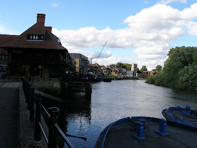
Karl Moritz approaches the Isleworth bank - # 157

For those interested: my research is based on the British Ordnance Survey map 1816-1822, plus careful reading of Karl Moritz's letters, visits to the local museum, and research on the local system of small rivers. I have recently found some misinterpretations and will correct those later. For the time being we should keep up the momentum. The Richmond/Kew/ Hounslow area is closely associated with the early history of official map-making thanks to George III's enthusiastic cooperation with the French Government. The French asked Britain to help with the survey of the English Channel coastal area in 1783. For once, Britain and France were (briefly) at peace. Unfortunately, by 1790 we were again fighting. In 1791 Britain started the official "Ordnance Survey" map making process, allegedly as a direct result of the earlier French initiative in cooperation. We can all be grateful to those men of science who undertook that initiative to cooperate.


I have to agree that the Ordnance Survey 1:50000 Rangefinder and to a lesser extent 1:25000 Pathfinder maps are the best maps I have ever used. That is, for what maps are best for, navigating, orienting and exploring - just as you've done. Motor atlases? Don't get me started. OS are closely followed by the Swiss and French from my European experience.
ReplyDeleteI really liked this photo--and all the historical information regarding map making around the area.
ReplyDeleteNice bluish cast on the water and the blue sky.
So, Richard and you are map experts! (My only sports medal, in 1967, comes from orientation!) Now I use Google Earth and GPS.
ReplyDeleteSo we have a proof that British and French CAN work together!
This is a really beuatiful view!
Yes, I trust you will soonest correct your errors; don't want to be cheated!
Hey where did you find that bit of blue sky?! I must have blinked and missed it today ..
ReplyDeleteAwesome photo!! And I love reading Karl Moritz's journey via your blog.
ReplyDelete